
Latest Swordfish satellite tag has popped off
by RFA of NSW 17 Dec 2021 23:09 UTC
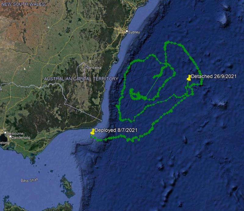
Latest Swordfish satellite tag has popped off © RFA of NSW
A satellite tag deployed by Al McGlashan on a swordfish off Mallacoota as few months ago has popped off and transmitted its data. The estimated 90 kg fish was tagged in early July by Al and Cooper McGlashan and popped off well offshore of Batemans Bay at the end of September.
The depth data shows that the fish carried out the typical pattern of diving deep during the day (to around 500 - 650m+) and rising near to the surface at night. There looks to have been a minor change to the behaviour around early to mid-September where the daytime dives don't go as deep as normal (300 - 450m+) before the normal pattern of dives to 500m+ resumed.
The surface water temperature increased (from around 16 degrees C) as the fish moved north from Victorian waters up to NSW waters, with the surface temperature reaching over 20 degrees for a period of over a week in early August. The swordfish appears to travel east from its tagging location and then north to a point directly east of southern Sydney before moving west towards the bottom of the continental slope and then tracking back south towards the border with Victoria before moving northeast up to the point of pop-off, east and well offshore of the Batemans Bay area.
DPI is undertaking this project in collaboration with the Australian National Sportfishing Association (NSW) and NSW Game Fishing Association with funds supplied by the NSW Recreational Fishing Licence Trust. The data from this project will also be used as part of a larger project being undertaken by Dr Sean Tracey, Institute for Marine and Antarctic Studies (IMAS), with similar objectives completed in Tasmania and currently under way in Victoria (both supported by funds from FRDC and a Victorian Recreational Fishing Grant).